Bayawan
Bayawan City (in Tagalog Lungsod ng Bayawan und in Cebuano Dakbayan sa Bayawan) ist eine Component City in der Provinz Negros Oriental auf der Insel Negros auf …
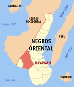
| Bayawan City | |||
| Lage von Bayawan City in der Provinz Negros Oriental | |||
|---|---|---|---|

| |||
| Basisdaten | |||
| Region: | Central Visayas | ||
| Provinz: | Negros Oriental | ||
| Barangays: | 28 | ||
| Distrikt: | 3. Distrikt von Negros Oriental | ||
| PSGC: | 074606000 | ||
| Einkommensklasse: | 2. Einkommensklasse | ||
| Einwohnerzahl: | 117.900 Zensus 1. August 2015
| ||
| Einwohnerdichte: | 168,7 Einw. je km² | ||
| Fläche: | 699,08 km² | ||
| Koordinaten: | 9° 22′ N, 122° 46′ O | ||
| Postleitzahl: | 6221 | ||
| Bürgermeister: | German P. Saraña, Jr. | ||
| Website: | http://www.bayawancity.gov.ph/ | ||
| Geographische Lage auf den Philippinen | |||
| |||


Bayawan City (in Tagalog Lungsod ng Bayawan und in Cebuano Dakbayan sa Bayawan) ist eine Component City in der Provinz Negros Oriental auf der Insel Negros auf den Philippinen. Sie hat 117.900 Einwohner (Zensus 1. August 2015), die in 28 Barangays lebten. Sie gehört zur 2. Einkommensklasse der Gemeinden auf den Philippinen. 83 % der Fläche werden als ländlich, 14,7 % als partiell urbanisiert und 2,3 % werden als urban bezeichnet. Den Titel einer Component City erhielt die Großstadt am 23. Dezember 2000.
Sie liegt ca. 102 km nordwestlich von Dumaguete City, die Reisezeit beträgt ca. zweieinhalb Stunden mit dem Bus, mit dem Auto ca. zwei Stunden. Ihre Nachbargemeinden sind Santa Catalina im Süden, Basay im Westen, Tanjay City im Südosten, Bais City im Osten und Mabinay im Norden. Der schmale Küstenstreifen im Südwesten hat eine Länge von 15 km und liegt an der Sulusee. Im Nordwesten grenzt sie an Kabankalan City in der Provinz Negros Occidental. Die Fläche der Gemeinde von 699,08 km² entspricht ca. 13 % der gesamten Fläche der Provinz Negros Oriental. Die Topographie der Gemeinde wird als hügelig bis gebirgig beschrieben.
Barangays
|
|
|
|
Quellen
Content Disclaimer
Informasi ini disarikan dari Wikipedia dan disajikan kembali untuk tujuan edukasi. Konten tersedia di bawah lisensi CC BY-SA 3.0. Kami tidak bertanggung jawab atas ketidakakuratan data yang bersumber dari kontribusi publik tersebut.
- The information displayed on this website is sourced in part or in whole from Wikipedia and has been adapted for the purpose of restating it. We strive to provide accurate and relevant information, however:
- There is no guarantee of absolute accuracy. Wikipedia is an open, collaborative project that can be edited by anyone, so information is subject to change.
- It is not intended to constitute professional advice. The content displayed is for informational and educational purposes only. For important decisions (e.g., medical, legal, or financial), please consult a professional.
- Content copyright. Wikipedia is licensed under the Creative Commons Attribution-ShareAlike License (CC BY-SA). This means that content may be reused with appropriate attribution and shared under a similar license.
- Responsible use. Any risk arising from the use of information from this website is entirely the responsibility of the user.